The Hard Way or the Hard Way
- julietertin

- Oct 13, 2020
- 5 min read

Last week my good friend Amber flew down from our hometown in Minnesota to backpack through southwest Colorado together. Neither of us had explored that corner of the Rockies. We quickly realized there are no bad choices branching off US 550, aka the Million Dollar Highway (perhaps nicknamed for the million dollar views, or maybe it cost a million dollars per mile to carve out of Precambrian metamorphic rock, who knows). Except one: trying to coax the Corolla over talus passes at 11,000' when you accidentally take the wrong unpaved road. Paper maps, man. Soooo necessary. I will also admit that I was scouting the area because Ouray 100 is on my mind.
We decided to tackle as many ice lakes and summits as possible in three fully intense days, including a 14er. I have a lot of half draft lists in my head: mountains and races and places. Mt. Sneffels was on one of those crumpled lists. I mean, look at that beauty. A majestic and symmetrical relief against buttery aspens with perfect fall weather. If nature beckons, she was shouting at us.

Disclaimer: even though I'm fully undergoing my transition from ultrarunner to mountain ultrarunner, I've only climbed one 14er (the same one twice). Sure, I've run a lot of mountain trails all over the country, I live at elevation, I have a solid knowledge base of gear logistics and safety as an outdoor rock climber, but I'm no mountaineer. Yet.
'Sneffels' sounds adorable and cuddly. The standard route starts in a big open wildflower meadow called Yankee Boy Basin, and you can drive your car all the way up to 12,600'. The hike is only five miles round trip with 1,700' of climbing on a class 2+. She's the Queen of the San Juans. It is an acclaimed beginner route and a good intro to America's monsters.

The morning of the hike, I lay awake at sunrise staring at the ceiling. I was uninspired.
Mountains are like ultras: you approach them with respect and exhibit the highest integrity, the utmost humility. I almost felt like we were taking advantage of the Beauty. Or maybe it the opposite, we weren't taking advantage of her immense beauty. I grabbed my phone off the nightstand.
There is another approach via the south crest: 13 miles, 4,000' ascent, three alpine lake vistas, and no 4WD required since the trailhead starts so much lower. Perfect. No further info needed. I clicked the screen black and rolled over.
"Amber!" I whispered excitedly, "Are you awake? We have to leave right now."
"Ok," she stretched her arms and answered without hesitation. "I'll be ready in two."
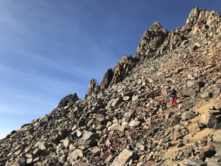
Had I scrolled just a bit further, I might have realized that the southwest ridge zippered up from the completely other side of the Queen (those aggressive spires on the left of the photo above). I might have noticed the route is a sandbagged class three many people climbers rope up and wear helmets to ascend. I might have scrolled through some route photos online and laughed to myself in my warm comfy bed.


Instead, I was already tying my boots. Playing it safe and short has never been my forte. I stayed sweetly unaware of the challenge ahead, although if I'm honest, somewhere I had a misgiving about it. I was oscillating at way too high a frequency on the drive to the Blue Lakes trailhead, the same pitch as the morning of an ultra.

Amber signed the trail log and I flipped through some loose pages. Stated destination? Blue Lakes Pass Blue Lakes Blue Lakes Pass Blue Lakes Pass the Blue Lake. A misgiving punched my gut. Why no summit fever? To my very small credit, I cautioned that there was probably a reason people weren't summiting. I mean, probably they were just soft.

The trailhead was well-trafficked. I felt safe. We began the first of two major sets of switchbacks up the mountain's shoulders into a sea of sunlit aspens. Starting at 10,000' the air was already thin. The altitude only gets more dizzying and punishing the higher you hike. We crossed the tree line and climbed into the high country.


A few miles in, we started finding the alpine lakes (there are actually four, not three). I can post a dozen photos, but the beauty is gargantuan. We saw a trout and had a snack.

Soon we hit miles of switchbacks that led up to a windy ridge: the base of the first of three false summits. But we didn't know that. We thought it was the base of THE summit. I mean, we could see the top. Lesson two: not only have a paper map, but read it.


The switchbacks stacked steeply like ramps etched out of a massive bald rockslide. Adorable little Rocky Mountain pikas cheered us on. We passed a handful of other hikers, but none we chatted with were summiting. When we finally reached the top, the trail clearly descended into the welcoming, warm Yankee Boy Basin while the summit spur turned sharply left into giant knifelike spires and disappeared onto pure loose talus. You could kind of make out the route. At least at first.
Then things got aggressive.


Hilariously aggressive. One or two small groups descended past us in their climbing gear. I had a skort and a baseball hat.

Altitude alone is a worthy adversary, it truly is. I've been hypoxic running above 10,000' (especially when you come from MN) and it's awful. You're trapped in a migraine and forced to function while growing increasingly desperate to inflate your lungs that never fill. You feel sleepy and lethargic, clumsy and foggy.
Add in exposure; I've felt that deep, terrifying chill of imminent free fall many times while climbing. Amber experienced the thrill of death's proximity alone on the unstable side of ancient volcanic remains. Exposure is primal fear. It's the inescapable realization that your life ends just below you, nearly within reach. It's as close as a poorly-judged handhold or one slip of a rock.

This is my last photo of the "easy" part of the ridge. After this, the route disappears and traverses completely open boulders with easily 40-100' of free fall onto rocks below. We had to scramble and climb around (and on) blank walls as well as deep gullies. The crux of the route is a massive, committing move up onto a ledge. As we approached it, two climbers were coming back down. "Fuck fuck FUUUUCK fuck don't drop me!" the woman kept screaming. It's always easier to go up things than come back down.

With this is mind, I evaluated our immediate situation. Was this careless? Most mistakes, injuries and death happen during the descent. I looked down at the major open air below us. "Considerable commitment" might be an understatement, 14ers.com. We continued up.

The first false summit led to a disappointing, taller second. The second false summit revealed an impossibly massive top-out on vertical bare boulders (how did we not see that earlier!). Many times I lost the route and had to rethink. There are maybe three cairns total. I later learned that the southwest approach is mostly unused because it's unprotected, unmarked, and demanding. Amber is a badass. A thousand times I thought she should've (and was about to) quit. Every time I turned around, she was still right behind me, pushing her limits while trying to slow her heart rate, which was beating like a snare drum to pump more Os into her bloodstream.

I would've felt a lot better with an alpine belay for the last 100 feet, but instead I brought a rain jacket and jolly ranchers, so no luck there. I kept checking my watch. Like Everest climbers (this was definitely our Everest that day), we agreed to turn back at a certain time no matter what. We had headlamps, but we needed to be back on solid trail before dusk. 3:30pm came quickly since the last push was so technical.

Summit victory is sweet.
Salty chips and guac in downtown Ouray after might possibly be even better.


Next time, we will still take the hard way.


link link link link link link link link link link link link link link link link link link link link link link link link link link link link link link link link link link link link link link link link link link link link link link link link link link link link link link link link link link link link link link link link link link link link link link link link link link link link link link link link link link link link link link link link link link link link link link link link link link link link link link link link link link link link link link link link link link